

For decades, pilots relied on paper charts, plotters, and manual calculations to navigate the skies. Today, with the tap of a finger, flight plans can be built, modified, and flown using digital maps and GPS-enabled tablets. This transition from analog to digital navigation has transformed general aviation and made flying safer, faster, and more accessible.
If you’re a student pilot or newly certified private pilot, chances are you’re learning to fly in a world where electronic flight bags (EFBs) and GPS-based navigation are the norm. But understanding how we got here, and how to use both traditional and modern tools, can make you a stronger and more versatile aviator.
A Brief History of Air Navigation
Early pilots navigated using visual landmarks, compasses, and basic maps. As aviation expanded, so did the need for more accurate and standardized methods.
The Birth of Aeronautical Charts
By the 1920s and 1930s, aeronautical charts were developed, offering pilots a top-down view of the terrain, airports, and airways. These early charts were simple but effective, helping aviators fly cross-country with reasonable accuracy.
VOR and Radio Navigation
In the 1940s and 1950s, radio navigation aids like the VOR (Very High Frequency Omnidirectional Range) revolutionized air travel. Pilots could now follow invisible radial lines in the sky, improving navigation precision. This led to the development of standardized airways and the sectional charts we know today.
The Age of GPS
In the 1990s, GPS (Global Positioning System) became available for civilian aviation. With accurate position data updated every second, GPS began to replace traditional navigation techniques and paper-based systems.
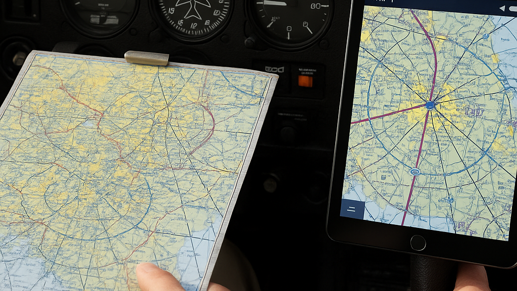
The Role of Paper Charts
For many years, paper charts were the cornerstone of VFR (Visual Flight Rules) and IFR (Instrument Flight Rules) navigation.
These charts included:
- Sectionals: Used for VFR navigation, showing terrain, landmarks, airspace, and airports.
- Enroute Charts: Used for IFR navigation between fixes or VORs.
- Terminal Area Charts (TACs): Offered detailed airspace layouts around major airports.
- Approach Plates and Procedures: Paper copies of instrument approach, departure, and arrival procedures.
Pilots learned to:
- Plot courses with a straightedge and plotter
- Measure distances and headings
- Calculate wind correction angles
- Interpret complex symbology
This method worked, but it required significant time, accuracy, and regular chart updates. For cross-country flying, you had to bring the right chart for each region, and missing one could mean trouble.
The Transition to Digital Navigation
In the early 2000s, digital flight planning tools started to become more common. Software like Jeppesen’s FliteStar and Garmin’s early mapping systems allowed pilots to plan routes on a computer.
Then came the game changer: the iPad.
The iPad Era Begins
In 2010, the introduction of the Apple iPad combined portability, long battery life, and touchscreen convenience. Aviation app developers quickly saw the opportunity, and within a few years, apps like ForeFlight and Garmin Pilot had become essential tools in the cockpit.
Suddenly, pilots could carry every chart in the country, plus weather, NOTAMs, airport data, and GPS-based navigation, all in one device.
Advantages of Digital Navigation
- Real-Time Position Awareness: With GPS integration, digital apps show your aircraft’s exact location on a moving map. You always know where you are in relation to airspace, terrain, and airports.
- Instant Flight Planning: Create a route in seconds, drag and drop waypoints, and get instant calculations for headings, distances, and estimated times.
- Automatic Updates: No more marking revisions on paper charts. Digital charts update automatically every cycle, ensuring you have the latest information.
- Built-In Weather and NOTAMs: See METARs, TAFs, radar imagery, and TFRs in real time. You can plan smarter by avoiding bad weather and restricted areas.
- Reduced Cockpit Clutter: One device replaces a stack of paper charts, approach plates, and airport directories. This simplifies cockpit organization, especially in small GA aircraft.
- Enhanced Safety Features: Many apps offer alerts for terrain, traffic, airspace incursions, and altitude deviations. Some even provide glide range rings, synthetic vision, and emergency procedures.
Common Tools in Today’s Digital Cockpit
Electronic Flight Bags (EFBs)
An EFB is any tablet or device used to view charts, plan flights, and access aviation data. The most common platforms include:
- ForeFlight: A top-rated app for iPad and iPhone, offering complete VFR and IFR capabilities.
- Garmin Pilot: Similar features with Garmin hardware integration.
- WingX, FltPlan Go, and others: Offer free or lower-cost options for flight planning and navigation.
Panel-Mounted GPS Systems
Units like the Garmin GTN series or Avidyne IFD series provide touchscreen navigation with GPS, terrain, traffic, and weather overlays. These systems often mirror the capabilities of tablet apps but are certified for IFR use.
ADS-B Receivers
Devices like the Sentry or Stratus receive traffic and weather data and feed it into your EFB. This gives you near real-time situational awareness in flight.
When and Why to Use Paper Charts
Despite the rise of digital tools, paper charts are still important for three main reasons:
- Backup: Electronics can fail. Batteries die, apps crash, and screens go blank. Paper charts serve as a reliable backup when needed.
- Checkrides and Training: Many checkrides still require knowledge of paper chart reading, especially at the private pilot level. Instructors often use paper for teaching fundamental navigation and airspace understanding.
- Visual Planning: Some pilots prefer the big-picture view offered by a full-sized sectional chart when planning complex routes.
Learning Both Systems
As a student or new private pilot, it’s smart to be proficient with both paper and digital navigation. Here’s how to approach your training:
- Start with the basics. Learn how to read sectional charts, plot courses, and calculate headings manually. This builds a foundation that helps you use digital tools more effectively.
- Use digital tools early. Get familiar with ForeFlight or Garmin Pilot as soon as your instructor allows. Practice entering flight plans, reading maps, and checking weather.
- Simulate failures. Practice flying with the EFB turned off. Know how to navigate using your paper chart and compass in case of device failure.
- Review frequently. Use online courses, tutorials, or your CFI to keep current with app updates and best practices.
Challenges of Digital Navigation
While digital tools offer many benefits, they also come with risks if not used carefully:
- Distraction: It’s easy to spend too much time looking at the screen. Remember to keep your eyes outside the cockpit and scan for traffic.
- Overreliance: GPS tells you where you are, but you still need to know what to do with that information. Always keep your skills sharp.
- Data Management: Download charts, updates, and weather before each flight. Don’t rely on a signal in the air.
- Legal Use: In some cases, only certain digital tools are legal for IFR flight. Make sure your devices and apps meet FAA requirements if you’re flying on instruments.
The Future of Navigation
Navigation technology continues to advance. Here are some trends you may see in the near future:
- More AI-assisted route planning
- Voice-controlled cockpit tools
- Wider use of synthetic vision and augmented reality
- Integration with drones and traffic systems
- Cloud-based syncing of flight data across devices
As technology evolves, pilots must stay informed and adapt without losing the core skills of airmanship and decision-making.
Final Thoughts
From the early days of compass navigation to the high-tech tools in today’s cockpits, aviation has always been driven by innovation. The transition from paper charts to digital systems marks one of the most significant shifts in modern flight training and private aviation.
As a student or newly minted pilot, embracing digital tools can help you fly more confidently and safely. But understanding how to navigate without them is just as important. Learn both. Master both. And always be ready to fly the airplane, not just follow the screen.
Sources:
– FAA: *Aeronautical Chart User’s Guide*
– ForeFlight: *Pilot Resources and Tutorials*
– AOPA: *The Evolution of Navigation*
– Garmin: *Using EFBs in the Cockpit*
– FAA AC 91-78: *Use of Electronic Flight Bags*
Recent Posts
How Synthetic Vision Systems Help Pilots See Through Anything
Imagine flying through dense clouds, over unfamiliar terrain, or during a dark night approach and still having a crystal-clear view of the world outside. That’s what synthetic vision systems offer...
Flight Simulators: How Technology Is Training Today’s Pilots
When you think of pilot training, you probably picture flight time in a real airplane. But technology has added an important new dimension to aviation education: flight simulators. Whether you’re a...